What path to the future?
Google Maps is preparing to roll out major AI-powered improvements in the coming weeks and months.
The five new AI-powered features, which are already rolling out to some users, will allow users to “plan and navigate trips with confidence, make sustainable decisions, and get quick inspiration on things to do.” According to Google.
Here’s what to look for as the changes come online.
Immersive view
Users will be able to see a more detailed preview of each part of a trip, whether driving, walking or cycling.
All you have to do to see your entire route in a multi-dimensional view is select the directions you want and tap the Immersive View preview.
There are visual turn-by-turn directions and a time slider that helps plan when to leave, based on information such as simulated traffic and weather conditions.
According to Google, iOS and Android users can experience the feature right now for trips to Amsterdam, Barcelona, Dublin, Florence, Las Vegas, London, Los Angeles, Miami, New York, Paris, San Francisco, San Jose, Seattle , Tokyo and Venice.
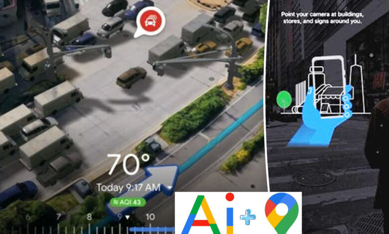
Lens on maps
Lens in Maps, formerly Live View Search, uses AI and augmented reality (AR) to help you get a sense of your surroundings and acclimatize.
Tapping the Lens icon in the search bar and picking up your phone will give you visual information about nearby ATMs, transit stations, restaurants, coffee shops and stores, whether you’re in a new city or looking for a new place. local.
Lens in Maps is rolling out to more than 50 new cities, including Austin, Las Vegas, Rome, São Paulo and Taipei, in the “largest expansion of this feature yet.”
Google Maps Navigation
Navigation on Google Maps will soon more accurately reflect the “real world” thanks to AI. The update will include improved colors, more realistic buildings to help orient yourself, and updated lane details to help prepare for “some of the most complicated driving maneuvers” on the roads.
These updates will soon roll out to 12 countries, including the US, Canada, France, and Germany.
For the US only, navigation will inform you if there are HOV lanes on your route. For Europe, AI-based speed limit information will expand to 20 countries.
Electric Vehicle Charging Station Information
Travelers driving electric vehicles will never have to worry about finding their next charge again.
Drivers will now be able to see more information, such as whether a charger is compatible with their vehicle; whether the available chargers are fast, medium or slow; and when the charger was last used, all of which will help avoid wasted time and disappointment.
The update has begun rolling out “wherever EV charging station information is available.”
Google Map Search
Google Maps’ updated search option will help users “find inspiration in a whole new way.”
Searching for specific things will produce top photo results based on analysis of billions of community-provided photos on Google Maps. Simply tap a photo to get more information and continue from there.
The feature has started rolling out in France, Germany, Japan, the UK, and the US, and will expand to more countries over time.
Plus, if you’re bored and not sure what to do, you can type “things to do” to see a list of themed results that you can even save to refer to later. This feature will be rolled out globally in the coming weeks.