I-90 reopens in New York after snowstorm pummels Great Lakes with more than 5 feet of snow

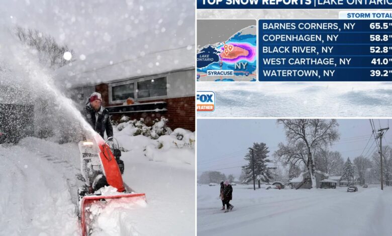
BUFFALO, N.Y. – A long-duration lake-effect snowstorm is continuing to pummel the Great Lakes region after dumping 3-5 feet of snow in cities from Michigan to New York that paralyzed travel as people tried to get home after the busy Thanksgiving holiday weekend.
This has been the first significant lake-effect snowfall of the season, and snow totals have been nothing less than epic in numerous communities.
The highest snowfall totals so far have been found in cities and towns downwind of Lake Erie and Lake Ontario from northwestern Pennsylvania to western and northern New York state.
Portions of Ohio, too, have been impacted, and forecasters say more winter weather is on the way before the system begins to finally wind down on Tuesday.
The impacts from the historic lake-effect snowstorm have been far-reaching, not only because of the sheer amount of snow that fell but also because of the intense snowfall rates reaching up to 4 inches per hour, which overwhelmed crews who were relentlessly working around the clock to remove the snow and ice from roads and highways such as the heavily traveled Interstate 90 from New York state to Ohio.
I-90 had been closed along that busy stretch due to dangerous winter weather that had affected travel in the region.
However, thanks to the hard work of Department of Transportation crews across the region, I-90 was first reopened to passenger travel late Saturday in portions of New York, and the highway fully reopened to both passenger and commercial vehicles early Monday morning.
Travel is expected to remain treacherous in areas still impacted by bands of heavy snow coming off the Great Lakes. Drivers are being urged to stay off the roads if possible, significantly slow their speeds, and leave plenty of distance between vehicles to ensure the safety of people out and about on Monday.
Dangerous travel conditions have been reported for days, with FOX Weather Storm Tracker Brandon Copic witnessing vehicles struggling to make it through the snow as it was falling.
“Honestly, it’s just chaos out here,” Copic said on Saturday from Erie, Pennsylvania. “The trucks are going on roads they shouldn’t be going because the highways are closed, and that just leads to more cars getting stranded.”
Copic said he spent hours on Friday trying to help those who became stranded in the extreme weather conditions. Copic also sent in drone video that showed stranded vehicles on Pennsylvania’s Route 5 near the border with New York that showed cars and trucks stuck in the snow.
“The trucks that are jackknifed up the road is what caused the gridlock,” he said.
States of emergency have been declared in three states – New York, Pennsylvania and Ohio – and National Guard troops had been called up to help with the storm response efforts.
And it wasn’t just the snow that was making headlines over the weekend. The paralyzing lake-effect snowstorm also produced rare thundersnow and even waterspouts off the shores of Lake Erie.
A video shared by Copic showed lightning flashing in the sky as the snow fell in Blasdell, New York, and loud rumbles of thunder could be heard in another video shared outside the Buffalo, New York, area.
Similar to thunderstorms, thundersnow requires a significant amount of atmospheric instability, and in areas where the phenomenon occurs, snowfall rates can be exceptionally heavy.
Winter weather alerts remain in effect across the region, including Lake-Effect Snow Warnings from Cleveland to southwestern New York that will remain in effect until at least Tuesday morning.
Winter Weather Advisories also remain in effect for parts of central New York, including the Syracuse metro, where several waves of lake-effect snow will impact the area through Tuesday afternoon.


