A massive, ultra-destructive severe thunderstorm complex tore across South Dakota on Monday morning, unleashing unprecedented straight-line winds that rival the power of a major tornado.
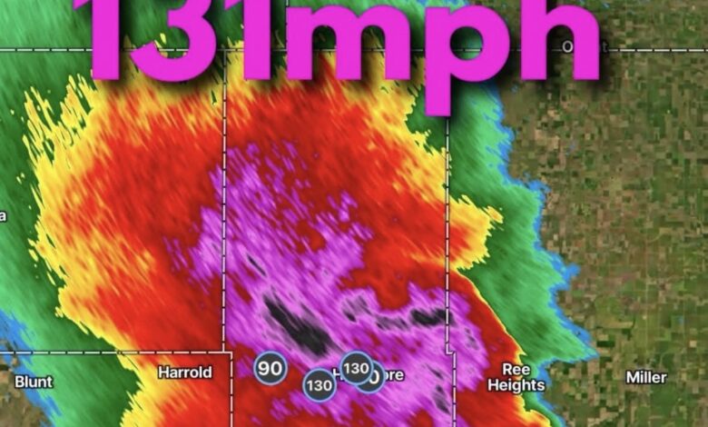
The National Weather Service (NWS) and local emergency management tracked the ferocious system as it pushed northeastward, generating maximum wind gusts of 131 mph recorded near Highmore and Holabird. For context, meteorologists note that 131 mph winds carry the destructive energy equivalent to an EF2 or near-EF3 tornado, capable of tearing roofs off homes, flattening buildings, and obliterating trees and utility infrastructure.
Double Threat: Extreme Velocity and Lemon-Sized Hail
Compounding the crisis, the storm’s intense supercell characteristics produced a core of massive, wind-driven hail. Reports across northern and central parts of the state—stretching across regions from Lemmon over toward the southwest of Aberdeen—indicated hail sizes reaching up to 2 to 3 inches in diameter (lemon to teacup-sized).
When giant hail is paired with 100+ mph straight-line velocities, the results are catastrophic:
- Property Damage: Shingles completely stripped, vinyl siding shredded, and windows punched through on countless homes and vehicles.
- Agricultural Impact: Crop fields in the path of the storm have been utterly shredded, dealing a devastating mid-summer blow to local farmers.
- Widespread Outages: Transmission lines and power poles have been snapped at the base, leaving thousands of residents without power as utility crews wait for conditions to stabilize.