Strong Santa Ana winds will continue to howl over much of coastal Southern California through midweek, creating a fast-moving, life-threatening and highly destructive wildfire situation.
AccuWeather’s Ken Clark breaks down the drought and high wind conditions kicking off the early year, which is contributing to the multiple wildfires burning in the state’s southern region.
A serious wildfire situation has unfolded for coastal areas of Southern California as a powerful Santa Ana event that can even reach into the metro areas of Los Angeles and San Diego continues, AccuWeather meteorologists warn. As the Palisades, Eaton and Hurst wildfires rage, the risk of additional fast-moving and wind-driven infernos will persist through at least Thursday.
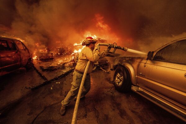
As those winds roared to life, several wildfires broke out Tuesday, burning thousands of acres in the Los Angeles area and forcing tens of thousands of evacuations. News sources are confirming the fires have turned deadly, with at least two fatalities thus far. Many homes have burned, and more are in the path of the fast-moving wildfires. As of the midday hours on Wednesday, the rapidly-spreading Eaton fire has consumed 10,600 acres, according to CalFire. The Palisades fire has grown to 11,800 acres.
The Palisades Fire burns vehicles and structures in the Pacific Palisades neighborhood of Los Angeles, Tuesday, Jan. 7, 2025.
“An area of high pressure over the Great Basin combined with a storm in northwestern Mexico has created the conditions for strong winds over Southern California starting on Tuesday,” said AccuWeather Meteorologist Gwen Fieweger. AccuWeather meteorologists began to warn of a significant Santa Ana and wildfire potential a week in advance.
These particular gusts, known as Santa Ana winds, will affect much of coastal Southern California into the end of the week with the strongest winds persisting through Wednesday and into Thursday.
“Wind gusts are expected to peak at 50-70 mph across portions of Southern California, with localized gusts of up to 80 mph,” according to Fieweger. This would be the case for communities like Santa Clarita and Riverside. An AccuWeather Local StormMax™ of 100 mph is most likely in the mountains.
Many hurricane-force wind gusts were recorded as of Wednesday morning. “For example, Hollywood Burbank Airport recorded a peak gust around 9 p.m. PST of 71 mph,” AccuWeather Meteorologist Danielle Ehresman said, “Additionally, gusts approaching 100 mph were recorded above 2,000 feet in the Santa Monica and San Gabriel mountains Tuesday night.”
According to PowerOutage.us, over 400,000 customers are without power in Southern California as of Wednesday morning. The majority of those are in Los Angeles County.
The setup is a bit different than most Santa Ana events. Strong winds will extend through some usually wind-protected areas near the Southern California coast. Downtown Los Angeles and San Diego are likely to escape the strongest winds; however, it could still be quite breezy, with gusts in excess of 30 mph.
Burning embers can be carried for miles to spark new pop-up fires that can grow rapidly in the high winds. Even the Los Angeles basin is at risk for spot fires due to large upstream blazes, such as the Eaton fire burning just northeast of the city.
Thousands flee, 2 dead as wind-driven wildfires rage across LA area
The force of the wind will also pack a punch in terms of impact. Winds of this magnitude will be capable of damaging poorly constructed structures and weakly rooted trees. Fieweger also warned that transportation, especially on major interstates, could be impacted due to dangerous crosswinds. Major airports in Southern California could also experience delays.
“The combination of gusty winds and lowering dew points (humidity) in the region will continue the fire risk into the end of the week,” said Fiewger.
Winds are expected to subside from Thursday to Friday as the storm moves away from Southern California. However, breezy conditions can make battling existing fires extremely difficult, and the risk of new fires starting from burning embers will continue.
Winds may never completely drop off over coastal Southern California into next week.
“A minor pulse of wind or minor Santa Ana event seems likely from Thursday night to Friday morning, then there is increasing concern for a significant Santa Ana (high wind) and wildfire threat from Monday to Tuesday of next week,” AccuWeather Senior Meteorologist Dave Houk said. Any breeze can fan the flames of ongoing fires and burning embers and sparks could trigger more blazes.


